Stay Up To Date
16″ POLITICAL RAISED-RELIEF GLOBE
Focuses on the world’s political organization into countries and states, but with 3-D shaded relief and sophisticated details (like city population ranges).
16″ LAND COVER RAISED-RELIEF GLOBE
Focuses on major ecological regions: cropland, grassland, desert, tundra, glaciers, and three types of forests.
16″ SCULPTURAL RAISED-RELIEF GLOBE
Seven colors express elevations on land, and three shades of blue express ranges of ocean depth.
12″ SCULPTURAL RAISED-RELIEF GLOBE
Seven colors express elevations on land, and three shades of blue express ranges of ocean depth.
16″ EARLY LEARNING RAISED RELIEF GLOBE
For the least experienced students, this globe introduces the continents, oceans, and cartographic conventions.
16″ READINESS RAISED RELIEF GLOBE
Focuses on countries and states, and on more advanced map conventions like latitude and longitude.
16″ INTERMEDIATE POLITICAL RAISED RELIEF GLOBE
Focuses on countries and states, but adds more detail, like capital and major cities.
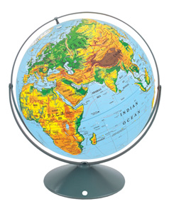
16″ INTERMEDIATE PHYSICAL RAISED RELIEF GLOBE
Focuses on Earth’s environments: its forest, grassland, desert, and alpine terrain regimes.
12″ EARLY LEARNING RAISED RELIEF GLOBE
For the least experienced students, this globe introduces the continents, oceans, and cartographic conventions.